Getting around Mexico City: metro, Metrobús, Uber and walking
What is the best way to get around Mexico City?
For tourists: Uber and DiDi for most journeys (reliable, safe, English-language apps, 40–120 MXN per trip in central areas). The metro (5 MXN flat fare, 12 lines) is the fastest option during rush hour on main corridors. Walking is excellent in Roma, Condesa, Coyoacán, and Centro Histórico. Metrobús is useful for the Reforma corridor and airport link.
The transport picture in brief
Mexico City has one of the most extensive urban transport systems in the Americas. The metro alone carries over 5 million passengers daily on 12 lines, covering most of the urban area. Add the Metrobús network, a vast array of colectivo minibuses, Ecobici bike share, and the now-ubiquitous Uber and DiDi, and the practical problem is not access to transport — it is choosing the right mode for each journey.
For tourists, the pragmatic answer is: walk what is walkable (Roma, Condesa, Centro, Coyoacán all reward it), take Uber or DiDi for most other journeys, and use the metro when the destination is well served by a station and you want to experience Mexico City’s extraordinary public transport system.
| Cheapest option | Metro, 5 MXN flat fare |
| Most convenient | Uber/DiDi, around 40–120 MXN per trip in central areas |
| Card needed | Tarjeta de Movilidad Integrada (10 MXN), for metro/Metrobús |
| Peak hours to avoid | 7:00–9:30am and 5:30–8:30pm on central metro lines |
| Best for walking | Roma, Condesa, Coyoacán, Centro Histórico |
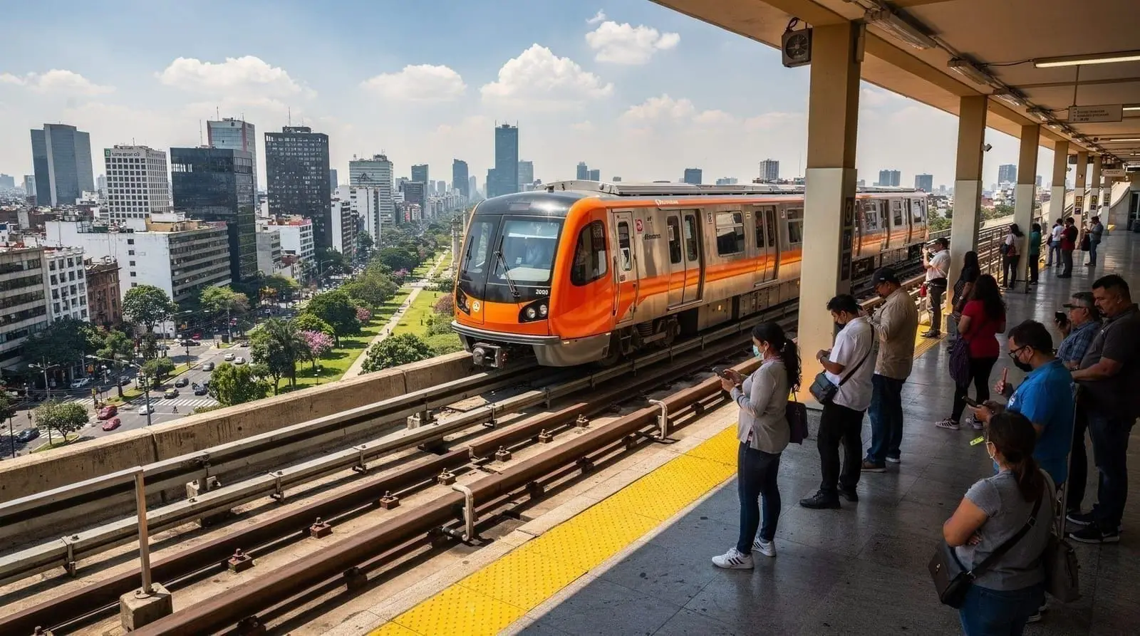
The metro: extraordinary value, requires some navigation
Mexico City’s metro (Sistema de Transporte Colectivo Metro, or STC Metro) is one of the world’s great urban transport systems by any measure. 12 lines, 195 stations, and a flat fare of 5 MXN make it unbeatable for cost. The network is colour-coded and stations are identified by unique pictograms (designed for literacy inclusivity when the metro opened in 1969), which helps navigation even for non-Spanish speakers.
Key lines for tourists:
- Line 1 (pink): Observatorio to Pantitlán — passes near Roma (Insurgentes, Sonora) and Centro (Balderas, Hidalgo, Zócalo/Pino Suárez)
- Line 2 (blue): Cuatro Caminos to Tasqueña — through Centro (Zócalo), useful for Centro connections
- Line 3 (olive/dark green): Indios Verdes to Universidad — Copilco and Universidad stations for UNAM/Coyoacán area; Insurgentes station for Roma
- Line 7 (orange): El Rosario to Barranca del Muerto — Polanco station for Polanco and nearby Anthropology Museum
Peak hours: 7:00–9:30 am and 5:30–8:30 pm on weekdays. The metro at these times is genuinely very crowded on the central lines — packed beyond what most Northern European or North American travellers are accustomed to. Outside peak hours it is comfortable and efficient.
Women-only policy: The front carriages of trains during peak hours are designated for women and children only. Signs are posted on the platform. This applies to several station areas as well (Mujeres/Niños section). Male travellers should not enter these carriages — this is enforced by staff at busy stations.
Luggage on the metro: Workable but uncomfortable with large suitcases at peak hours. See the airport transfer guide for the airport-to-city options comparison.
Metrobús: the BRT network
The Metrobús is a Bus Rapid Transit system on dedicated lanes, running on seven lines. It bridges gaps between metro coverage and is often faster than the metro on its specific corridors because the BRT lanes separate it from general traffic.
Key lines for tourists:
- Line 1: Indios Verdes to El Caminero — along Insurgentes, the city’s main north-south artery, passing Roma (Álvaro Obregón, Sonora) and Condesa (Campeche)
- Line 4: Buenavista to Terminal Área 2 — airport to city centre connection
- Line 7: Indios Verdes to Auditorio — along Reforma
Cost: Same 30 MXN fare as metro with the Tarjeta de Movilidad Integrada. The card works across both systems.
Uber and DiDi: the practical tourist choice
For most journeys that aren’t on a direct metro or Metrobús line — going to Coyoacán, getting to Xochimilco, late-night returns from dinner in Polanco — Uber or DiDi is the most comfortable, safe, and practical option.
Pricing: In-city journeys typically cost 40–120 MXN. Roma to Coyoacán: 80–120 MXN. Roma to Polanco: 60–100 MXN. Surge pricing applies during peak hours, rain, and major events. Airport runs are described in the airport guide.
Data requirement: Both apps require a mobile data connection to order. Get a local SIM card from Telcel or AT&T on arrival (available at airport vendors and everywhere in the city) or use a roaming international plan. A local SIM for 7 days of data costs approximately 150–200 MXN. Having data is essential for Uber as the primary transport tool.
Language: Both Uber and DiDi have English-language interfaces. Many drivers in tourist-area neighbourhoods have some English. Knowing the destination name in Spanish helps — share the map pin or use the address directly in the app rather than explaining verbally.
Safety reminder: Always confirm driver name, photo, and plate before entering. Never get into a car that approaches you without matching the app booking.
Taxis: only official ones
As covered in the common scams guide and safety guide, unmarked street taxis (libres) should be avoided entirely. The risks are real.
Safe taxi options:
- Sitio taxis (radio dispatch, from hotel stands, shopping centres, or specific taxi stands)
- Official airport taxis from the counter
- Taxis from the app Taxi Seguro (authorised service in some areas)
For most purposes, Uber or DiDi provides the same service with better safety and price transparency.
RTP: the free public buses
RTP (Red de Transporte de Pasajeros) is the city’s free bus network — a fleet of orange buses covering routes the metro and Metrobús don’t reach directly. They are genuinely free (no card or cash needed) but slower, more crowded, and less predictable than the paid systems, with route information mostly in Spanish and less oriented toward first-time visitors.
Most tourists never need RTP because Uber/DiDi and the metro cover the relevant tourist corridors, but it is worth knowing it exists if you end up somewhere the metro doesn’t reach and a taxi isn’t handy — Google Maps includes RTP routes in its transit directions. Some RTP routes also run trolleybuses (electric, overhead-wire buses) on longer corridors, which are quieter and slightly more comfortable than the diesel fleet, though you won’t be able to choose which type shows up at a given stop.
Renting a car: usually not worth it
Driving yourself in Mexico City is rarely a good idea for visitors. Traffic is dense and can be aggressive, parking in the popular neighbourhoods (Roma, Condesa, Centro) is scarce and often informally “managed” by a franelero (informal parking attendant) expecting a tip, and the extensive Uber/metro/walking combination covers nearly every visitor need at a fraction of the hassle.
A car becomes worth considering only if you are planning to drive onward to somewhere like Valle de Bravo or Tepoztlán independently and want the flexibility of your own schedule rather than a bus or tour — even then, many visitors find it easier to book a driver or a day-trip tour for these routes rather than navigate Mexican highway driving norms (topes/speed bumps, toll roads, and variable signage) for the first time on a short trip.
Ecobici bike share
Roma and Condesa are among the most cycle-friendly neighbourhoods in Mexico City, with dedicated cyclovías and calm residential streets. Ecobici’s 480+ stations make it practical to hire a bike for short trips between these neighbourhoods.
How it works: Download the Ecobici app or use the kiosk at any station. Register with a credit card. A single 45-minute trip costs 25 MXN. Longer trips add fees per additional 30 minutes. A tourist day pass (all day, unlimited 45-minute trips) is available.
Where it works well: Roma → Condesa (10 minutes on bike, Avenida Amsterdam is traffic-calmed); Roma → Chapultepec; Reforma boulevard (Sunday Ciclovía has the entire avenue closed to cars). The Sunday morning Ciclovía on Paseo de la Reforma (7 am to 2 pm) is one of Mexico City’s best free experiences — the city’s main boulevard becomes a cyclist and pedestrian park.
Where it doesn’t: Outside Roma/Condesa/Polanco/Centro, cycling infrastructure thins out and regular traffic lanes require confidence. Do not cycle to Coyoacán or Xochimilco from the centre — too far and too varied in road quality for casual cyclists.
A guided bike tour of the historic centre is an excellent introduction to cycling in the city if you want to explore by bike with a local guide who knows the safe routes.
Walking: the underused mode
Walking in Mexico City in the right neighbourhoods is genuinely excellent. The weather (17–25°C during dry season) is perfect for on-foot exploration; the architecture rewards slow movement; and the street food is accessible at every corner.
Best walking neighbourhoods:
Roma Norte and Roma Sur: A morning walk from Álvaro Obregón south through the colonias, stopping for coffee at Café Avellaneda or Café Tomás, browsing independent bookshops, and ending at Parque Bello is 2–3 hours of pure pleasure.
Condesa: Avenida Amsterdam’s oval circuit (about 2.3 km) past the jacarandas, Parque México, and the Art Deco apartment buildings.
Coyoacán: The historic centre around the twin plazas (Jardín Hidalgo and Jardín Centenario), the market, and the quieter streets behind the church. See the Coyoacán walking guide for a mapped route.
Centro Histórico: The pedestrian axis from Bellas Artes east along Madero Street to the Zócalo is about 15 minutes of walking past some of the city’s most remarkable architecture, including Palacio de Correos (the ornate post office), Casa de los Azulejos (a 16th-century building tiled in blue and white), and the Palacio de Bellas Artes.
Polanco: The Masaryk and Presidente Mazaryk boulevard — Mexico City’s luxury shopping street — has pleasant pedestrian sections, good café stops, and leads naturally to the Chapultepec park entrance.
Getting to day trip destinations
Teotihuacán: 50 km north. Best accessed by a tour that includes transport (avoids the bus terminal experience) or by driving. Independent access: Autobuses del Norte terminal (Metro La Raza or Deportivo 18 de Marzo on Line 5), then Autotransportes México-San Juan Teotihuacán bus (every 30 minutes, 45–55 MXN each way).
Xochimilco: 25 km south. Uber is easiest (40–70 MXN). Metro Line 2 to Tasqueña, then Tren Ligero (light rail) to Xochimilco station for the DIY option.
Tepoztlán: 90 km south. OCC/Estrella Roja buses from Tasqueña terminal, 1.5 hours. Uber/taxi 90–120 minutes.
Puebla: 130 km east. ADO buses from TAPO (Terminal Oriente) or Observatorio terminal, 2–2.5 hours, 200–350 MXN. Direct door-to-door by Uber: 2 hours, approximately 800–1,200 MXN.
Navigation apps and staying connected
Google Maps is reliable for Mexico City and includes metro, Metrobús, and RTP routing alongside driving and walking directions — it is the single most useful tool for getting around, and works well even with patchy data since it caches routes once loaded. Download the offline map for the city centre before you arrive in case of connectivity gaps. Both Uber and DiDi need a live data connection to function, which is the main reason a local SIM or eSIM is worth arranging on arrival rather than relying solely on hotel wifi — see the airport arrival guide for where to buy one on the way into the city.
Integrated Mobility Card
The Tarjeta de Movilidad Integrada (previously called Tarjeta CDMX) is the unified payment card for metro, Metrobús, Tren Ligero (light rail to Xochimilco), and public buses. Available at metro stations and Metrobús terminals for 10 MXN. Load it with credit at automatic machines or windows. You will want at least 50–100 MXN loaded to cover a day of public transport.
Practical transport costs summary
| Mode | Single journey (central area) | Daily budget |
|---|---|---|
| Metro | 5 MXN | 20–40 MXN |
| Metrobús | 30 MXN | 60–90 MXN |
| Uber/DiDi | 40–120 MXN | 200–400 MXN |
| Ecobici (casual) | 25 MXN/45 min | 100–200 MXN |
| Official airport taxi | 280–400 MXN (one-off) | — |
For a budget traveller using metro + Metrobús: 50–100 MXN/day. For a comfort traveller using Uber for everything: 300–500 MXN/day.
Frequently asked questions about getting around Mexico City
Is there an Oyster-style card for all Mexico City transport?
Yes — the Tarjeta de Movilidad Integrada works across metro, Metrobús, Tren Ligero, and most public bus routes. It is not yet valid for Uber/DiDi (which take card payments via app), but covers the full formal public transport network.
Can I use contactless payment on the metro?
Some stations have NFC card readers, but coverage is not universal and the system can be unreliable. The mobility card remains the most consistent payment method. Check at the station you are using — if there is a contactless reader, tap with your card or phone; if not, use the card.
Is ride-sharing safe late at night?
Uber and DiDi are the safe option for late-night transport in Mexico City. In Roma, Condesa, and Polanco, ordering an Uber at 1:00 am is straightforward and safe. Availability may be slightly lower at very late hours — if you cannot get a ride within 5 minutes, DiDi typically has better late-night coverage in some areas. Walking home from late restaurants in Roma and Condesa is fine on the main streets; for deeper residential streets or after 1:00 am, use an app.
Is there a tourist pass for Mexico City transport?
As of 2026, there is no single tourist transport pass covering all modes. The mobility card is the closest equivalent for public transport. A Turicard pass covers entry to 40+ attractions but not transport specifically.
How do I read the metro map?
The metro map uses lines by colour and stations by name plus a unique pictogram symbol — you can navigate entirely by colour and symbol without knowing Spanish. The map is available free at station exits and in digital form. Google Maps has Mexico City metro integrated and will give you exact routing with transfer instructions.